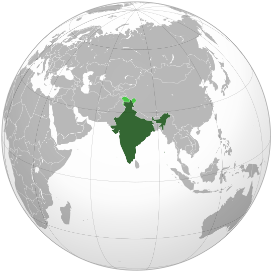
Bestand:India (orthographic projection).svg

Afbeelding in hogere resolutie (SVG-bestand, nominaal 541 × 541 pixels, bestandsgrootte: 280 kB)
Dit bestand is afkomstig van Wikimedia Commons en kan ook in andere projecten gebruikt worden. De bestandsbeschrijvingspagina wordt hieronder weergegeven.
Beschrijving
| BeschrijvingIndia (orthographic projection).svg |
English: India. Area controlled by India in dark green; claimed but not controlled areas in light green. |
|||||
| Datum | ||||||
| Bron |
Own work, Deze vectorafbeelding is gemaakt met Inkscape . Aquarius.geomar.de
|
|||||
| Auteur | Ssolbergj (talk) | |||||
| Andere versies |
Afgeleide werken van dit bestand:
العربية: الرجاء، قراءة الميثاق.
বাংলা: দয়া করে, রীতিনীতিটি পড়ুন।
Deutsch: Bitte lies die Konventionen.
English: Please, read the conventions.
Español: Por favor, lea las convenciones.
Filipino: Paki-basa ang mga kumbensyon.
Français : S'il vous plaît, lisez les conventions.
हिन्दी: कृपया सभागमों को पढ़ लें.
Bahasa Indonesia: Silakan, baca konvensi.
Italiano: Si prega di leggere le convenzioni.
日本語: 規約をご確認ください。
ქართული: გთხოვთ, გაეცნოთ კონვენციებს.
Македонски: Ве молиме, прочитајте ги општоприфатените правила.
Português: Por favor, leia as convenções.
Русский: Пожалуйста, прочитайте соглашения.
Tagalog: Paki-basa ang mga kumbensyon.
Українська: Будь ласка, прочитайте конвенції.
Tiếng Việt: Hãy đọc công văn trước khi đăng.
|
Licentie

|
Toestemming wordt verleend voor het kopiëren, verspreiden en/of wijzigen van dit document onder de voorwaarden van de GNU-licentie voor vrije documentatie, versie 1.2 of enige latere versie als gepubliceerd door de Free Software Foundation; zonder Invariant Sections, zonder Front-Cover Texts, en zonder Back-Cover Texts. Een kopie van de licentie is opgenomen in de sectie GNU-licentie voor vrije documentatie.http://www.gnu.org/copyleft/fdl.htmlGFDLGNU Free Documentation Licensetruetrue |
- De gebruiker mag:
- Delen – het werk kopiëren, verspreiden en doorgeven
- Remixen – afgeleide werken maken
- Onder de volgende voorwaarden:
- naamsvermelding – U moet op een gepaste manier aan naamsvermelding doen, een link naar de licentie geven, en aangeven of er wijzigingen in het werk zijn aangebracht. U mag dit op elke redelijke manier doen, maar niet zodanig dat de indruk wordt gewekt dat de licentiegever instemt met uw werk of uw gebruik van zijn werk.
- Gelijk delen – Als u het werk heeft geremixt, veranderd, of erop heeft voortgebouwd, moet u het gewijzigde materiaal verspreiden onder dezelfde licentie als het oorspronkelijke werk, of een daarmee compatibele licentie.
Bijschriften
Waarde zonder Wikidata-item
november 2008
image/svg+xml
Bestandsgeschiedenis
Klik op een datum/tijd om het bestand te zien zoals het destijds was.
| Datum/tijd | Miniatuur | Afmetingen | Gebruiker | Opmerking | |
|---|---|---|---|---|---|
| huidige versie | 26 apr 2023 09:10 |  | 541 × 541 (280 kB) | Swtadi143 | Reverted to version as of 07:34, 16 September 2021 (UTC) siachen glacier is fully controlled by india and not india pakistan jointly, see Siachen conflict for context. |
Bestandsgebruik
Dit bestand wordt op de volgende 2 pagina's gebruikt:
Metadata
Dit bestand bevat aanvullende gegevens, die waarschijnlijk door een fotocamera, scanner of fotobewerkingsprogramma toegevoegd zijn.
Als het bestand is aangepast, komen sommige details mogelijk niet overeen met het gewijzigde bestand.
| Breedte | 541.48 |
|---|---|
| Hoogte | 541.48 |


