Bestand:PBW March 1919.png
Naar navigatie springen
Naar zoeken springen


Grootte van deze voorvertoning: 782 × 600 pixels. Andere resoluties: 313 × 240 pixels | 626 × 480 pixels | 1.001 × 768 pixels | 1.280 × 982 pixels | 2.000 × 1.534 pixels.
Afbeelding in hogere resolutie (2.000 × 1.534 pixels, bestandsgrootte: 347 kB, MIME-type: image/png)
Beschrijving
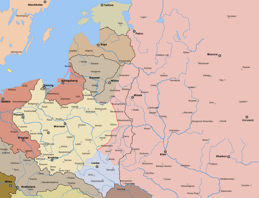
English: Frontlines of the Polish-Bolshevik War in March of 1919
Post-war borders from 1920s marked with black
Polski: Front polsko-bolszewicki w marcu 1919. Uwaga: Poza tym frontem użyte są ostateczne granice z lat 20.
Since the legal status of the above comment has been questioned, I hereby grant anyone the right to treat it as either a standard copyright notice, invariant section, legal statement, legal advice, friendly suggestion or a mere comment, depending on his or hers own choice. |
|

Other versions

|
Bestand:PBW March 1919.svg is een vectorversie van dit bestand. Indien niet van slechtere kwaliteit dient deze gebruikt te worden in plaats van deze rasterafbeelding.
File:PBW March 1919.png → File:PBW March 1919.svg
Zie Help:SVG voor meer informatie. |
 |
Afgeleide werken van dit bestand: PBW March 1919.svg
The following is a list of maps created by Halibutt and uploaded to commons, as well as their present and projected derivatives.
| Parent Image | Image | Description | |||||||||||
|---|---|---|---|---|---|---|---|---|---|---|---|---|---|
| Maps by Halibutt | |||||||||||||
| Image:Rzeczpospolita.png | Image:Rzeczpospolita.png | The Republic in 17th and 18th century | |||||||||||
| Image:Rzeczpospolita 1600.png | The Republic after the Treaty of Dywilino | ||||||||||||
| Image:Rzeczpospolita voivodships.png | Voivodships of The Republic | ||||||||||||
| Image:Rzeczpospolita_Potop.png | The Republic during The Deluge and Chmielnicki Uprising, with major battles of the era marked | ||||||||||||
| Magnates and their lands and domains | |||||||||||||
| 1st • 2nd • 3rd | Partitions of Poland | ||||||||||||
| War of the constitution | |||||||||||||
| Image:Rzeczpospolita.xcf | SOURCE FILE - GIMP format | ||||||||||||
| Image:Poland 1939.png | Image:Poland 1939.png | Poland in 1939 | |||||||||||
| Image:Dywizje wrzesien 1.png | Order of Battle on September 1st, during the Polish Defence War of 1939 | ||||||||||||
| Image:Poland 1939.xcf | SOURCE FILE - GIMP format | ||||||||||||
| Image:Polska kontur bialy.png | Image:Polska kontur bialy.png | Contour map of Poland AD 1999, for use with various locator maps | |||||||||||
| Image:Rzeczpospolita 1923.png | Image:Rzeczpospolita 1923.png | Map of Poland 1918-1939, currently under development | |||||||||||
| Image:PBW March 1919.png | Polish-Bolshevik War - fronts in March of 1919 | ||||||||||||
| Image:PBW December 1919.png | Polish-Bolshevik War - fronts in December of 1919 | ||||||||||||
| Image:PBW June 1920.png | Polish-Bolshevik War - fronts in July of 1920 | ||||||||||||
| Image:PBW August 1920.png | Polish-Bolshevik War - fronts in August of 1920 | ||||||||||||
| Polish Defence War of 1939 | |||||||||||||
| Polish areas annexed by Germany, Lithuania, Slovakia and the Soviet Union | |||||||||||||
| German concentration camps in Poland | |||||||||||||
| Curzon line | |||||||||||||
| Major battles of the Polish-Bolshevik War | |||||||||||||
| names • no names | Polish/Czechoslovak/Lithuanian/German/Ukrainian claims in 1920's | ||||||||||||
| Image:Rzeczpospolita Central Lithuania.png | Central Lithuania | ||||||||||||
| Image:Rzeczpospolita Lithuania claims.png | Central Lithuania as compared with other Lithuanian claims | ||||||||||||
| Image:Rzeczpospolita 1789-1920.png | Post-1922 borders compared with the territory of Poland before the partitions | ||||||||||||
| Warsaw Uprising and the Operation Tempest | |||||||||||||
| Poland partitioned between the Soviets and the Germans | |||||||||||||
| Image:Rzeczpospolita 1939 Polish divisions.png | Polish divisions on September 1, 1939 | ||||||||||||
| Home Army inspectorates | |||||||||||||
| Image:Rzeczpospolita 1922.xcf | SOURCE FILE - GIMP format | ||||||||||||
| Image:Rzeczpospolita 1937.svg | Vector version!!!! | layered version available on request | |||||||||||
Bestandsgeschiedenis
Klik op een datum/tijd om het bestand te zien zoals het destijds was.
| Datum/tijd | Miniatuur | Afmetingen | Gebruiker | Opmerking | |
|---|---|---|---|---|---|
| huidige versie | 3 nov 2019 22:48 | | 2.000 × 1.534 (347 kB) | Claude Zygiel | Lituanian hold march 19 |
Bestandsgebruik
Dit bestand wordt op de volgende pagina gebruikt: