Bestand:Alemannisch.png
Naar navigatie springen
Naar zoeken springen

Grootte van deze voorvertoning: 422 × 599 pixels. Andere resoluties: 169 × 240 pixels | 338 × 480 pixels | 423 × 600 pixels | 541 × 768 pixels | 722 × 1.024 pixels | 1.831 × 2.598 pixels.
Afbeelding in hogere resolutie (1.831 × 2.598 pixels, bestandsgrootte: 1,07 MB, MIME-type: image/png)
| Beschrijving |
Alemannisch:
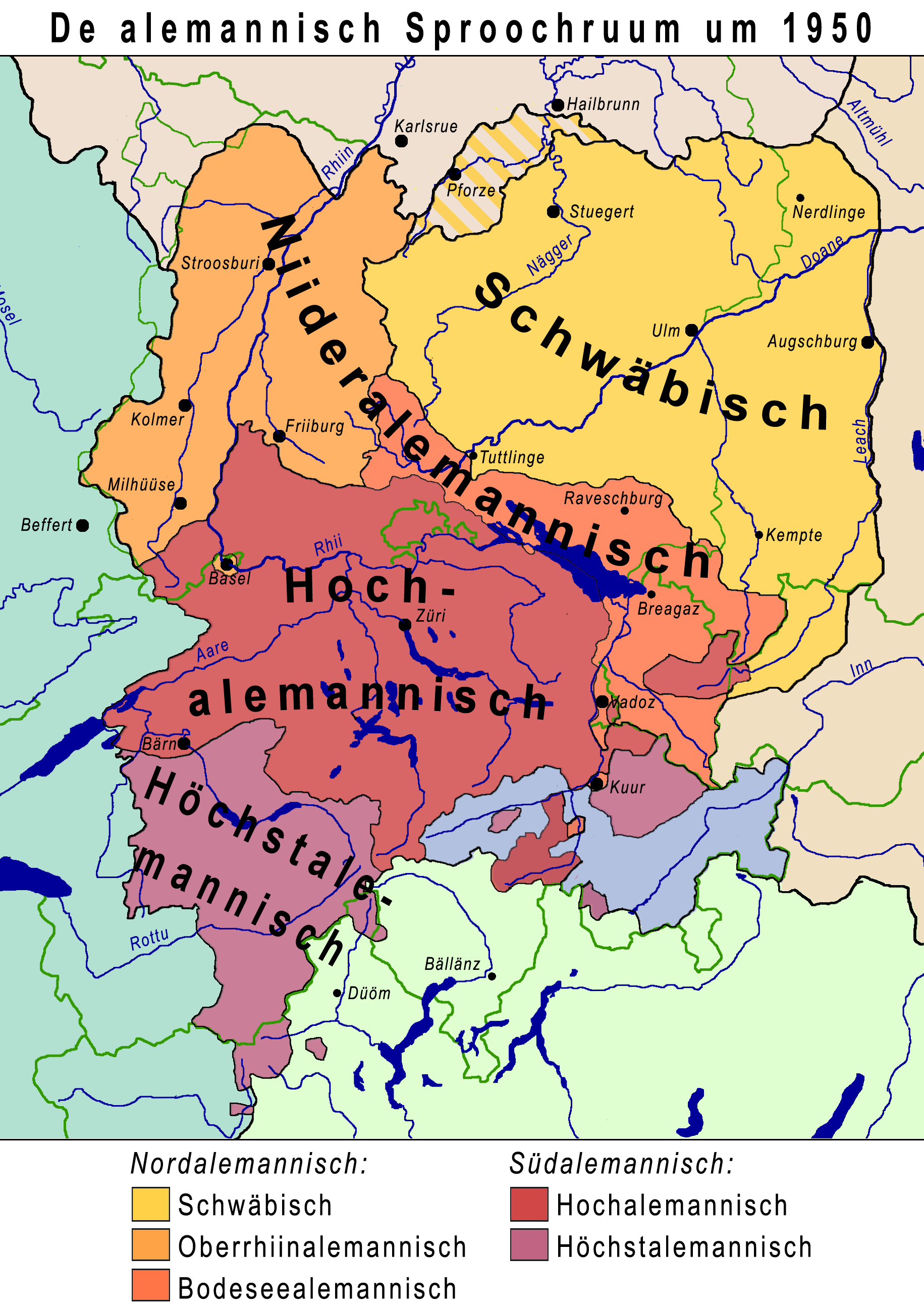
English: The Alemannic speech area, based on the division made by Karl Bohnenberger. The isoglosses have been corrected based on the dialect surveys of the Alemannic speech area. The terms and definitions of Oberrhiinalemannisch (Upper-Rhine Alemannic) and Bodeseealemannisch (Lake Constance Alemannic) have been added according to the proposals of Hugo Steger. The Map is based on the linguistic state of 1950. Since then, Alemannic has gained ground in the Canton Grisons in favour of Romansch; outside of Switzerland, Alemannic has been pushed back, especially in urban agglomerations. This can be observed most strongely in Alsace (France). The border between Swabian and Lake Constance Alemannic has dissolved and moved southward.
Català: Diagrama de l'àrea lingüística de l'alamànic, basat en les divisions que va fer en Karl Bohnenberger. Les isoglosses s'han corregit segons la literatura disponible. Els termes Oberrhiinalemannisch (alamànic de l'alt Rin) i Bodeseealemannisch (alamànic del llac de Constança) s'hi han afegit d'acord amb les propostes d'en Hugo Steger. El mapa es basa en l'estat lingüístic de 1950. Des d'aleshores, l'alamànic ha guanyat terreny al cantó de Grisons a costa del romanx; fora de Suïssa, l'alamànic ha retrocedit, especialment als nuclis urbans fenòmen observable especialment a l'Alsàcia. La frontera entre el suabi i l'alamànic del llac de Constança d'ha dissolt i mogut cap el sud. |
| Datum | |
| Bron |
Drawn and moved from the Alemannic Wikipedia; References:
|
| Auteur |
|
| Toestemming (Hergebruik van dit bestand) |
Dit bestand is gelicenseerd onder de Creative Commons-licentie Naamsvermelding-Gelijk delen 2.5 Unported
|
| Andere versies |
Afgeleide werken van dit bestand: AlemByspylsatz Ort1.svg PNG:
PNG:
SVG:
SVG: SVG:
|


Picture keys
Color code Dialect Northern Alemannic Yellow English: SwabianAlemannisch: SchwäbischCatalà: suabiOrange English: Upper-Rhine AlemannicAlemannisch: OberrhiinalemannischCatalà: alamànic de l'alt RinRed English: Lake Constance AlemannicAlemannisch: BodeseealemannischCatalà: alamànic del llac de ConstançaSouthern Alemannic Dark-red English: High AlemannicAlemannisch: HochalemannischCatalà: alt alamànicPurple English: Highest AlemannicAlemannisch: HöchstalemannischCatalà: alamànic superior
Ruum, wo abgränzt wird Isoglosse Schwäbisch/Niideralemannisch Hous/Huus Niederalemannisch/Hochalemannisch Kopf/Chopf Hochalemannisch/Höchschtalemannisch trinkche/triiche
Bestandsgeschiedenis
Klik op een datum/tijd om het bestand te zien zoals het destijds was.
| Datum/tijd | Miniatuur | Afmetingen | Gebruiker | Opmerking | |
|---|---|---|---|---|---|
| huidige versie | 13 jul 2007 12:56 | | 1.831 × 2.598 (1,07 MB) | Terfili | Category:Alemannic |
Bestandsgebruik
Dit bestand wordt op de volgende pagina gebruikt: